Followers

Thursday, May 7, 2020

2020 24 Mar - 05 Apr Kodachrome Basin, Grosvenor Arch and more Bryce Canyon


Kodachrome Basin State Park, Utah - 24 March 2020
A lovely day for a family hike up onto the mesa. This State Park was the closest place to our campsite at Cannonville, Utah. The colors and contrasts of the towering sandstone chimneys prompted the National Geographic Society to name the park Kodachrome in 1949, with consent of the Kodak Film Corporation. 
False trails kept us on our toes to stay on the correct path. Tori likes to lead and has a good nose for picking the right way to go. Nearly 70 monolithic spires up to 170 feet jut up from the valley floor or protruding from the sandstone.
Expansive views across southern Utah and towards Arizona. Caution is needed though because the edges of these trails had been sufficiently saturated by recent rains to have them crumble under foot of the unwary. 
After climbing up for our first hike, we walked along the valley floor to reach the two box canyons. Several rock slides from the sides of the canyon walls show how fragile sandstone can be when exposed to wind and rain. 
Dead end at the box canyon. And the swirling winds caused grit to fly into our eyes. Even the dogs were sneezing from it. But there were also amazing things etched from those very same winds.
Sedimentary pipes are the most distinctive feature of the park. They are large columns of sedimentary rock that rise from the basin floor but geologists are unsure of their exact origin. Earthquakes may have caused course, water-saturated sediments to scout pathways through overlying rock layers then recement becoming harder than the surrounding rock. Over time, erosion has removed the softer layers. OR they are the remnants of ancient springs which became choked with sediments, which cemented together and became more erosion resistant than the surrounding rock. These softer layers were eventually worn away, exposing the sedimentary pipes. 

Return to Bryce Canyon, Utah - 26 March 2020
Beyond the Bryce Amphitheater trails and overlooks is the less traveled road south following the canyon along its narrow areas. The 18 mile road is closed during winter but had reopened recently. Many of the pull-outs were completely empty of others. We were glad we had gotten out our winter coats. With the wind blowing in gusts of 25 mph the air temperature was at freezing but the wind chill was in the low 20s. 
Natural Bridge, a window through solid rock. Created in a thin wall of rock called a fin, frost-wedging enlarges cracks in the fins, creating holes which are eroded out by wind and rain into windows. Eventually the sides of the windows will collapse under the weight of the top.  
Social distancing was still our priority but once again while enjoying the scenery we had someone crowding into our space. It was frustrating because there is clearly enough room at these pull-outs for everyone to maintain the recommended distance and still enjoy the views. 
Almost at 9,000 feet, and winter still retains its grip on the north facing slopes. The trees beyond the canyon walls are part of the Dixie National Forest. Many settlers were from the deep south. Since the St. George area was warm like the deep south and they could grow cotton for the Mormon Church, they started calling it Utah's "Dixie".
A small pullout to one of the less-visited overlooks. This one demonstrates just how precariously the cliffs drop from the road.
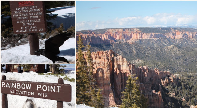
End-of-the-road. Yovimpa and Rainbow Points are the final destinations and highest elevations at over 9100 feet. Check out the amount of snow, almost 4 feet. And that is after several days with temperatures warm enough to melt snow. 
The southern exposure canyon walls are virtually cleared of snow. Local ravens "camp out" in the parking areas waiting for handouts. Cliffs come up very quickly when you are focused on the expansive scenery of the canyons.  
The cliff steepness and amount of snow pack had caused several visible mini avalanche slides. Miles of spires, some dusted with snow, while others are gathering sunshine.

Grosvenor Arch and Willis Creek Slot Canyon, Utah - 
30 March 2020
Just past the Kodachrome State Park turn-off, the road continues southeast towards the Grosvenor Arch.We were amazed at the intelligence of the local livestock to know exactly where the designated crossings were located.
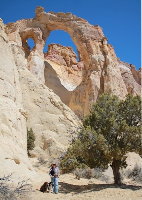
Along a bumpy dirt road, through miles and miles of sagebrush on rolling terrain, the sheer and colossal cliff structures are massive. Two sandstone arches towering 150 feet above the ground is a unique feature, and one of the biggest arches, within the Grand Staircase-Escalante National Monument in southern Utah. The arch(es) were named in 1949 to honor Gilbert Hovey Grosvenor, a president of the National Geography Society and first full-time editor of the namesake magazine. 
                                           
Actually two connected arches, the larger one is nearly 100 feet in diameter. The paved path from the parking area to the base continues around on an unmarked trail leading behind the massive sandstone formation and places you at the top of the ridge in close proximity, and almost equal height, to the arches. Let's go!

Watch your distance and footing. There are no railings and one false step will become a 150 fall. But look at the views.
From the trailhead to Willis Creek Slot Canyon there is nothing impressive about this hike. But after walking along the creek bed for awhile things start to change. 
This may not be as grand as Antelope Slot Canyon (which had been closed due to Covid-19 infection rates on the Navajo reservation) but we got the feel for the majestic ability of nature to create a beautiful sculpture with the basics of life - water. Hopping back and forth over the creek as it winds its way through the canyon, the walls keep the temperatures mild.
No need for guides or equipment, technical descents, tricky approaches or special navigation. This is so simple even a dog can manage on her own four feet. The refreshing waters are only a couple inches deep so wading is an option.  
Before descending into the canyon, the creek churns along, crystal clear and noisy, dropping dozens of feet into boulder surrounded pools. Very chilly from snow melt in the nearly by hills.

Third trip to Bryce Canyon - 31 March 2020

Our third trip into Bryce Canyon for a hike into the amphitheater. Queens Garden trail is very popular but we were lucky to only have a dozen or so other hikers along the way. 
Again, watch your footing as you walk along as there are no guardrails and many turns to gradually descend to the valley floor.
Some man-made doorways, the only wildlife other than birds and lots of hoodoos and spires at which to marvel. 
It just does not seem possible for all the variety of rock formations to be present in one location. Every direction shows unique and splendid views with dramatic changes in coloration and light. 
At the very bottom of the canyon, when you least expect it and only from the vantage point of the information plaque, do you get to see the reason why this is called the Queen's Garden. A singular rock formation that appears to look very similar to the statue in London, England of Queen Victoria. 
As usual, there are the scavengers where hikers replenish their strength for the return trek. The Stellar's jay is the only crested jay west of the Rocky Mountains and frequently scavenges picnic and camp sites where they exploit human-provided food sources.

Bleaching up after grocery shopping - 1 April 2020


Last trip to Bryce Canyon - 5 April 2020
Any hiking takes preparation but who would think face masks would become a necessary part of our gear. This hike along the snow covered Bristlecone Loop required boots, winter socks and several layers for core warmth. Somewhere under all this snow is the trail. In this case, just follow (warily) the footprints. 
Spectacular views and the short, easy to miss bristlecone pine and cones. Bob is trying to decide on the proper path while I am stuck in a deep pocket which collapsed under my boot up to my knee. This was the most troublesome event of the hike. A dozen or more times one foot is 18 inches below the other which may or may not have solid footing. Cold and icy.
A final look at the Amphitheater. There is no trick photography. It is truly as magnificent as it seems. Stay Safe. Wash your hands.

No comments:

Post a Comment