Followers

Tuesday, April 21, 2020

2020 Mar 20 - Mar 22 Cannonville, Anasazi State Park and Bryce Canyon

Cannonville/Bryce Canyon, Utah - 20 March 2020
We arrived at our new campground on March 19. The next day around 12 pm we had snow showers and by 2 pm it cleared. Still needed to get out the winter coats so we could take the dogs for a nice walk around the campgrounds. 

Anasazi State Park and Museum, Boulder, Utah - 21 Mar 2020
Day trip up the Scenic Byway 12 through the Grand Staircase Escalante to an Ancestral Puebloan village. These ruins have been reconstructed due to fire damage. Referred to as the Coombs Village Site, this is another of the hundreds (perhaps thousands) of Anasazi Villages. This site is believed to have been occupied from 1160 AD to 1235 AD.
Though largely unexcavated, this 6-acre site has numerous storage areas, above and below ground living areas and community gathering areas. This is one of the largest Anasazi communities known to have existed west of the Colorado River. 
Driving home we stopped at several pull-outs along the road through the Grand Staircase Escalante. And there are rivers and ponds fed by the run-off and snow melt so yes, there are ducks in the desert and Fremont cottonwoods which grow along the riparian zones. Made up of streams, rivers, springs, seeps, wetlands and alluvial bottom lands these trees are native to southwestern United States and Mexico. 

Snow remains on all heights of over 6,000 feet. 
At lower elevations a herd of elk grazing and relaxing. 

Bryce Canyon National Park, Utah - 22 March 2020
First trip into Bryce Canyon comes after the beginning of closures for the Coronavirus. It was not clear what we were going to find. Not only were the campgrounds closed for the winter, there was several feet of snow in some locations. The lodge was still open so we did see many people hiking into the canyon and around the rim. Though the Visitors' Center was closed, the General Store and Gift Shop were open with limits of 10 people. 
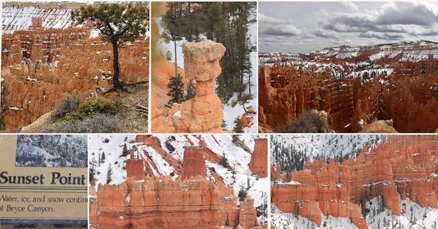
These photos do not do justice to the formations and waves of crimson-colored hoodoos or spire-shaped rock formations.  
It's pliant branches give it the common name "Limber Pine". Seeds take root and as the tree grows erosion from rain, snow and wind begin to strip the soil from around the roots. Left exposed each specimen in the Canyon looks like the tree is standing on spindly legs. 
Today's hike is from Sunrise to Sunset Point, along the rim. Bryce Canyon is the largest concentration of hoodoos found anywhere on earth. There is also the Queen's Garden trail leading into the canyon. The park's high elevation include numerous life communities, fantastic dark skies and geologic wonders. 
Depending on the exposure, the sides of the canyon can be clear to completely snow covered. Trails are also impacted by their exposure, elevation and tree cover. Our hike had sections that were clear and dry, muddy with puddles and completely snow covered and difficult to traverse. 
Upper, middle photo is Thor's Hammer from Sunset Point. 
Hiking back from Sunset Point. At these high elevations, spring comes in fits and starts. Those plants that begin growing are frequently buried under more snow. Ever few feet the scenery changes and exposes new views. 
                                           
Looking back towards Sunrise Point. View of the snow covered Grand Staircase Esclante.

Interesting grooves on tree trunk. All downed trees are left by the National Park Service to decay naturally. At this altitude and dry conditions these trees can take decades to decay. The wildlife use these trees as caches for the pine nuts they gather. 
We saw several odd things like a Bat Box and several dead trees with large spiral splits running dozens of feet up their trunks. We could not think of any explanation for it. A Clark's Nutcracker is busy collecting pine nuts. A very odd spire formation.   
Views from Inspiration point.  Couple on Bryce Point. Raven in flight. The mass of spires was not visible from the trail between Sunrise and Sunset Points. Quite a surprise as Inspiration Point is reached by walking up a hill so the vista is not visible until we actually reached the railing.  
Bryce Amphitheater is the park's most iconic area. Named for Ebenezer Bryce, who settled in the valley just below the canyon in 1870. Scottish by birth, Bryce was a shipbuilder who journeyed west with Brigham Young and the Mormon pioneers to assist in construction of building essential to community life. He and his wife, Mary, lived here for only 5 years while he oversaw construction of a timber road to the rim and a 7-mile irrigation canal from Paria Creek, both vital to the area's development as a ranching and farming community. Lower right Wall of Windows.


More Bryce to come.


No comments:

Post a Comment