Followers

Monday, May 25, 2020

2020 04 06 - 04 09 Kanab UT, 04 10 - 04 14 Cortez CO, 0415 - 04 18 Grand Junction CO, 04 19 - 0424 Craig CO

Kanab, Utah - 6 Apr-9 Apr 2020


Toadstools Hiking Trail, part of Grand Staircase-Escalante National Monument, Kanab, Utah - 7 Apr 2020  
Hiking to The Toadstools.  Not there yet. Family and dog friendly trail leads up to a wide, shallow canyon with rim walls striped in white, reddish brown and gold.
We have arrived at The Toadstool Hoodoos. Toadstools are geologic features that have a hard cap rock that sits on top of a more easily-weathered sandstone tower, and resemble large mushrooms. Hoodoos are wider, oddly-shaped towers without the rock cap.
Hiking beyond the Toadstools, we are trying to get a view of the surrounding area from a higher elevation. Off in the distance several trails lead away across the basin but end up disappearing over a rise.  

Canyons of the Ancients National Monument, Cortez, Colorado - 11 April 2020
We were unable to go to the Four Corners Monument due to the Navajo Tribal Nation having closed from Covid-19. But the BLM has many places with interesting areas to explore. Canyons of the Ancients encompasses 176,000 acres. The Monuments contains the highest known archaeological site density in the United States, with rich, well-preserved evidence of native cultures. Fortunately, there are plenty of signs posted to locate this archaeological site. 
This cultural landscape contains more than 6,355 recorded sites reflecting all the physical components of past human life: villages, field houses, check dams, reservoirs, great kivas, cliff dwellings, shrines, sacred springs, agricultural fields, petroglyphs and sweat lodges. The Monument has been used or inhabited by Northern Ancestral Puebloan culture (or Anasazi) for 10,000 years and continues to be used by humans today.  
Lowry Pueblo, begun in 1060 AD by Ancestral Puebloans starting with a few rooms and eventually building to include 40 rooms, eight kivas, and The Great Kiva-a large, circular subterranean rooms created for religious rituals and political purposes. The unique stone figures at the bottom of the Kiva have been interpreted as symbols of winter and summer people. Within these figures are four platforms for pillars to support a roof. 
Area scenery and wildlife, Sleeping Ute Mountain and La Plata Mountains plus a current resident.
Painted Hand Pueblo, Canyon of the Ancients, Colorado 
A short drive from Lowry Pueblo is the Painted Hand Pueblo. While Lowry was on a vast flat plain, the Painted Hand Pueblo is perched on a cliff and barely seen from the trailhead. 
The broken tower is the most obvious point of interest but we had to scale down the cliffside over large boulders and skittering stone slides to reach it. Tori, always up for an adventure, only had one spot that was too tall for her and had to be picked up (not her favorite thing). Unfortunately, there was no interpretive information posted so we just have to assume the tower was used to monitor the valley for game, travelers or enemies.
The namesake "Painted Hand" is a little difficult to see under the ledge behind the tower. Carol explains to Tori, "Yes, this is the trail", but Tori is not convinced. She made it down but it was the return trip up those rocks that caused concern.  

The Mesa Verde National was closed during our visit. It is well-preserved Ancestral Puebloan cliff-dwellings. It is thought that the Anasazi people from the plains abandoned their dwelling for the cliffs and created the over 600 dwelling that can be seen and explored when accessed by the stairs and ladders.

Arriving at Grand Junction, Colorado - 16 April 2020

Relaxing with some wine and snacks. 
Colorado National Monument, Grand Junction, Colorado - 17 April 2020
Preserving on of the grand landscapes in America, this is towering monoliths within a vast plateau and canyons. The Rim Rock Drive winds 23 miles up switchbacks onto the mesa tops. A serious feat of engineering.
While the literature suggests that bighorn sheep and soaring eagles may be seen, we have found these claims to be highly speculative. More often than not in our experience, soaring birds are vultures and land creatures are lizards or small rodents. 
But we certainly cannot complain about the expansive views. 


Rifle, Colorado - 18 Apr 2020
Local Art Sculpture updated for social distancing. And through this small western town the diversity of our country stood out. While some folks have a little bit of fun during the shutdown of the pandemic, we found ourselves driving along with a dozen or so caravan vehicles "protesting" with flags and signs. 

Craig Colorado - 20 April 2020
In the field behind the Craig KOA, our homestead for the next week, two pairs of Sandhill cranes. The immature pair (right) mostly walked around feeding while the adult pair gracefully glided across the field. Known as the "Elk Hunting Capital of the World" this remote town of about 10,000 people, there is also trout fishing, wild horses and dinosaur tracks. 

Day Trip west on Highway 40 and 318 - 20 April 2020
Vermillion Falls, Maybell, Colorado is in the Vermillion Basin, a 77,000 acre roadless area which has no established campsites, no maintained trails, and isn't even marked on most maps. We only knew about this little oasis by asking the campground owners. Spring and early summer brings the best flows on the Vermillion Creek in this high desert. 
Irish Canyon, another almost unknown area, remote and highly scenic canyon designated as an Area of Critical Environmental Concern (ACEC) because of its unique geology, scenery, plant species, and cultural resources. This area also harboured some of America's western outlaws in the 1900s: Butch Cassidy and the Wild Bunch, Matt Warner and Isom Dart. But the main attraction is the dozens of petroglyphs at the entrance of the canyon just off the road. Ancient Fremont Native Americans left the stories of their lives in this form of rock art.


Sand Wash Basin, our final destination and the real reason we drove to Craig, Colorado. The wild horses, numbering near 360 animals, are genetically based on Iberian Spanish breeds, followed by gaited breeds ("single-foots" - those always having one foot in contact with the ground), North American and Arabian breeds. 
There are over 90 bands numbering 3 to 12 members. A band's lead mare guides the band to watering holes, food and protection from weather while the stallion provides protection. Some individuals are seen "dogging" a small herd. 
This cute interaction suddenly turned more hazardous with hooves flying and teeth bared. All hostilities were over and calm returned in seconds. 
Pintos, grays, blacks, palominos, red and blue roans, bays and sorrels can be seen. We were very fortunate to have arrive in spring to see several foals. So adorable.  
Mostly interested in the sage and saltbrush vegetation, a variety of grasses comprise the majority of their diet. Springs and reservoirs provide much of their water throughout the year. But sometimes, one or two are just as curious about us. 
A new foal with mother and yearling sibling.  
Over the ridge, we were not sure what we were seeing but there were hundreds of them. Several herds of sheep (and their protective dog) and one lone pronghorn. They claim to also have sage grouse, coyotes, burrowing owls, elk and mule deer. While a couple of these would be too small to see from the road, we saw none on our visit. 
This is one of the largest band we observed. The biggest was nine members.
As the light began to fade, a final lone horse and a very skittish Golden Eagle. Every time we drove down the road to get a closer view, this eagle would take off for a distant telephone pole. This was so worth the time and less than ideal road conditions.  

Browns Park National Wildlife Refuge, Colorado - 22 April 2020

Just a nice day for an easy walk along Beaver Creek in the Wildlife Refuge. Do not get any hopes up because as usual, there are no namesake beavers here. But the end of the trail had a couple homestead buildings with an awesome view. I wonder, with water not being an issue, why abandon the farm? 
Here is the only wildlife (except for mallards and one wader), mule deer looking a little shaggy and thin from a long winter. 
Testing Bob's driving perception and my hand signal communication skills to navigate this single vehicle bridge. A rather tight squeeze we had to bring the side mirrors in . Just glad we did no try that with a dually. 
A rarity at any age, Ann Bassett, the first white child born in Browns Park Valley, became a rancher. She and her parents often did business with notable outlaws Butch Cassidy and Harvey "Kid Curry" Logan, selling them horses and beef. 
Drive in search of Elk - 24 Apr 2020
False alarm. A startled mule deer. We were told that south of Craig was an elk herd of almost 1000 head. The drive went on for 30+ miles through some lush farmland in the valley between two  ranges. May not have found the herd but the drive along the raging river was beautiful. 
Ah, finally. There are a few elk. Perhaps we should have waited until later in the afternoon to begin our trip. These elk were just appearing as we ended our drive and the sun was beginning to set behind the hills.  


Thursday, May 7, 2020

2020 24 Mar - 05 Apr Kodachrome Basin, Grosvenor Arch and more Bryce Canyon


Kodachrome Basin State Park, Utah - 24 March 2020
A lovely day for a family hike up onto the mesa. This State Park was the closest place to our campsite at Cannonville, Utah. The colors and contrasts of the towering sandstone chimneys prompted the National Geographic Society to name the park Kodachrome in 1949, with consent of the Kodak Film Corporation. 
False trails kept us on our toes to stay on the correct path. Tori likes to lead and has a good nose for picking the right way to go. Nearly 70 monolithic spires up to 170 feet jut up from the valley floor or protruding from the sandstone.
Expansive views across southern Utah and towards Arizona. Caution is needed though because the edges of these trails had been sufficiently saturated by recent rains to have them crumble under foot of the unwary. 
After climbing up for our first hike, we walked along the valley floor to reach the two box canyons. Several rock slides from the sides of the canyon walls show how fragile sandstone can be when exposed to wind and rain. 
Dead end at the box canyon. And the swirling winds caused grit to fly into our eyes. Even the dogs were sneezing from it. But there were also amazing things etched from those very same winds.
Sedimentary pipes are the most distinctive feature of the park. They are large columns of sedimentary rock that rise from the basin floor but geologists are unsure of their exact origin. Earthquakes may have caused course, water-saturated sediments to scout pathways through overlying rock layers then recement becoming harder than the surrounding rock. Over time, erosion has removed the softer layers. OR they are the remnants of ancient springs which became choked with sediments, which cemented together and became more erosion resistant than the surrounding rock. These softer layers were eventually worn away, exposing the sedimentary pipes. 

Return to Bryce Canyon, Utah - 26 March 2020
Beyond the Bryce Amphitheater trails and overlooks is the less traveled road south following the canyon along its narrow areas. The 18 mile road is closed during winter but had reopened recently. Many of the pull-outs were completely empty of others. We were glad we had gotten out our winter coats. With the wind blowing in gusts of 25 mph the air temperature was at freezing but the wind chill was in the low 20s. 
Natural Bridge, a window through solid rock. Created in a thin wall of rock called a fin, frost-wedging enlarges cracks in the fins, creating holes which are eroded out by wind and rain into windows. Eventually the sides of the windows will collapse under the weight of the top.  
Social distancing was still our priority but once again while enjoying the scenery we had someone crowding into our space. It was frustrating because there is clearly enough room at these pull-outs for everyone to maintain the recommended distance and still enjoy the views. 
Almost at 9,000 feet, and winter still retains its grip on the north facing slopes. The trees beyond the canyon walls are part of the Dixie National Forest. Many settlers were from the deep south. Since the St. George area was warm like the deep south and they could grow cotton for the Mormon Church, they started calling it Utah's "Dixie".
A small pullout to one of the less-visited overlooks. This one demonstrates just how precariously the cliffs drop from the road.
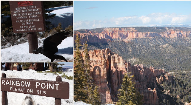
End-of-the-road. Yovimpa and Rainbow Points are the final destinations and highest elevations at over 9100 feet. Check out the amount of snow, almost 4 feet. And that is after several days with temperatures warm enough to melt snow. 
The southern exposure canyon walls are virtually cleared of snow. Local ravens "camp out" in the parking areas waiting for handouts. Cliffs come up very quickly when you are focused on the expansive scenery of the canyons.  
The cliff steepness and amount of snow pack had caused several visible mini avalanche slides. Miles of spires, some dusted with snow, while others are gathering sunshine.

Grosvenor Arch and Willis Creek Slot Canyon, Utah - 
30 March 2020
Just past the Kodachrome State Park turn-off, the road continues southeast towards the Grosvenor Arch.We were amazed at the intelligence of the local livestock to know exactly where the designated crossings were located.
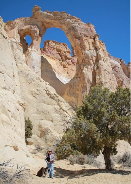
Along a bumpy dirt road, through miles and miles of sagebrush on rolling terrain, the sheer and colossal cliff structures are massive. Two sandstone arches towering 150 feet above the ground is a unique feature, and one of the biggest arches, within the Grand Staircase-Escalante National Monument in southern Utah. The arch(es) were named in 1949 to honor Gilbert Hovey Grosvenor, a president of the National Geography Society and first full-time editor of the namesake magazine. 
                                           
Actually two connected arches, the larger one is nearly 100 feet in diameter. The paved path from the parking area to the base continues around on an unmarked trail leading behind the massive sandstone formation and places you at the top of the ridge in close proximity, and almost equal height, to the arches. Let's go!

Watch your distance and footing. There are no railings and one false step will become a 150 fall. But look at the views.
From the trailhead to Willis Creek Slot Canyon there is nothing impressive about this hike. But after walking along the creek bed for awhile things start to change. 
This may not be as grand as Antelope Slot Canyon (which had been closed due to Covid-19 infection rates on the Navajo reservation) but we got the feel for the majestic ability of nature to create a beautiful sculpture with the basics of life - water. Hopping back and forth over the creek as it winds its way through the canyon, the walls keep the temperatures mild.
No need for guides or equipment, technical descents, tricky approaches or special navigation. This is so simple even a dog can manage on her own four feet. The refreshing waters are only a couple inches deep so wading is an option.  
Before descending into the canyon, the creek churns along, crystal clear and noisy, dropping dozens of feet into boulder surrounded pools. Very chilly from snow melt in the nearly by hills.

Third trip to Bryce Canyon - 31 March 2020

Our third trip into Bryce Canyon for a hike into the amphitheater. Queens Garden trail is very popular but we were lucky to only have a dozen or so other hikers along the way. 
Again, watch your footing as you walk along as there are no guardrails and many turns to gradually descend to the valley floor.
Some man-made doorways, the only wildlife other than birds and lots of hoodoos and spires at which to marvel. 
It just does not seem possible for all the variety of rock formations to be present in one location. Every direction shows unique and splendid views with dramatic changes in coloration and light. 
At the very bottom of the canyon, when you least expect it and only from the vantage point of the information plaque, do you get to see the reason why this is called the Queen's Garden. A singular rock formation that appears to look very similar to the statue in London, England of Queen Victoria. 
As usual, there are the scavengers where hikers replenish their strength for the return trek. The Stellar's jay is the only crested jay west of the Rocky Mountains and frequently scavenges picnic and camp sites where they exploit human-provided food sources.

Bleaching up after grocery shopping - 1 April 2020


Last trip to Bryce Canyon - 5 April 2020
Any hiking takes preparation but who would think face masks would become a necessary part of our gear. This hike along the snow covered Bristlecone Loop required boots, winter socks and several layers for core warmth. Somewhere under all this snow is the trail. In this case, just follow (warily) the footprints. 
Spectacular views and the short, easy to miss bristlecone pine and cones. Bob is trying to decide on the proper path while I am stuck in a deep pocket which collapsed under my boot up to my knee. This was the most troublesome event of the hike. A dozen or more times one foot is 18 inches below the other which may or may not have solid footing. Cold and icy.
A final look at the Amphitheater. There is no trick photography. It is truly as magnificent as it seems. Stay Safe. Wash your hands.