Followers

Tuesday, April 21, 2020

2020 Mar 20 - Mar 22 Cannonville, Anasazi State Park and Bryce Canyon

Cannonville/Bryce Canyon, Utah - 20 March 2020
We arrived at our new campground on March 19. The next day around 12 pm we had snow showers and by 2 pm it cleared. Still needed to get out the winter coats so we could take the dogs for a nice walk around the campgrounds. 

Anasazi State Park and Museum, Boulder, Utah - 21 Mar 2020
Day trip up the Scenic Byway 12 through the Grand Staircase Escalante to an Ancestral Puebloan village. These ruins have been reconstructed due to fire damage. Referred to as the Coombs Village Site, this is another of the hundreds (perhaps thousands) of Anasazi Villages. This site is believed to have been occupied from 1160 AD to 1235 AD.
Though largely unexcavated, this 6-acre site has numerous storage areas, above and below ground living areas and community gathering areas. This is one of the largest Anasazi communities known to have existed west of the Colorado River. 
Driving home we stopped at several pull-outs along the road through the Grand Staircase Escalante. And there are rivers and ponds fed by the run-off and snow melt so yes, there are ducks in the desert and Fremont cottonwoods which grow along the riparian zones. Made up of streams, rivers, springs, seeps, wetlands and alluvial bottom lands these trees are native to southwestern United States and Mexico. 

Snow remains on all heights of over 6,000 feet. 
At lower elevations a herd of elk grazing and relaxing. 

Bryce Canyon National Park, Utah - 22 March 2020
First trip into Bryce Canyon comes after the beginning of closures for the Coronavirus. It was not clear what we were going to find. Not only were the campgrounds closed for the winter, there was several feet of snow in some locations. The lodge was still open so we did see many people hiking into the canyon and around the rim. Though the Visitors' Center was closed, the General Store and Gift Shop were open with limits of 10 people. 
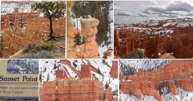
These photos do not do justice to the formations and waves of crimson-colored hoodoos or spire-shaped rock formations.  
It's pliant branches give it the common name "Limber Pine". Seeds take root and as the tree grows erosion from rain, snow and wind begin to strip the soil from around the roots. Left exposed each specimen in the Canyon looks like the tree is standing on spindly legs. 
Today's hike is from Sunrise to Sunset Point, along the rim. Bryce Canyon is the largest concentration of hoodoos found anywhere on earth. There is also the Queen's Garden trail leading into the canyon. The park's high elevation include numerous life communities, fantastic dark skies and geologic wonders. 
Depending on the exposure, the sides of the canyon can be clear to completely snow covered. Trails are also impacted by their exposure, elevation and tree cover. Our hike had sections that were clear and dry, muddy with puddles and completely snow covered and difficult to traverse. 
Upper, middle photo is Thor's Hammer from Sunset Point. 
Hiking back from Sunset Point. At these high elevations, spring comes in fits and starts. Those plants that begin growing are frequently buried under more snow. Ever few feet the scenery changes and exposes new views. 
                                           
Looking back towards Sunrise Point. View of the snow covered Grand Staircase Esclante.

Interesting grooves on tree trunk. All downed trees are left by the National Park Service to decay naturally. At this altitude and dry conditions these trees can take decades to decay. The wildlife use these trees as caches for the pine nuts they gather. 
We saw several odd things like a Bat Box and several dead trees with large spiral splits running dozens of feet up their trunks. We could not think of any explanation for it. A Clark's Nutcracker is busy collecting pine nuts. A very odd spire formation.   
Views from Inspiration point.  Couple on Bryce Point. Raven in flight. The mass of spires was not visible from the trail between Sunrise and Sunset Points. Quite a surprise as Inspiration Point is reached by walking up a hill so the vista is not visible until we actually reached the railing.  
Bryce Amphitheater is the park's most iconic area. Named for Ebenezer Bryce, who settled in the valley just below the canyon in 1870. Scottish by birth, Bryce was a shipbuilder who journeyed west with Brigham Young and the Mormon pioneers to assist in construction of building essential to community life. He and his wife, Mary, lived here for only 5 years while he oversaw construction of a timber road to the rim and a 7-mile irrigation canal from Paria Creek, both vital to the area's development as a ranching and farming community. Lower right Wall of Windows.


More Bryce to come.


Wednesday, April 1, 2020

2020 01-04 Mar: Las Vegas,NV and 05-18 Mar: Hurricane, UT

National Atomic Testing Museum, Las Vegas, Nevada - 2 March 2020
Downtown Las Vegas is not where we would have thought to find a Museum for atomic testing. Standing guard outside the Area 51 Theater is a prototype for the Lost in Space robot of "Danger, Will Robinson" fame. 
Desk of Frank H. Rogers, the first chief operating officer of the Nevada atomic testing site.
Map and fly over photo of the Trinity Test Site where the first nuclear device was detonated on 16 July 1945 as part of the Manhattan Project by the U.S. Army. The depressions in the landscape are from explosions conducted underground after above ground testing was banned. 
Dozens of items were produced during the 1950s and early 1960s of atomic bomb related products. Books, graphic novels, pamphlets, postcards and tourist items were made and donated. 
A deceased mountain lion was found near the testing site. American companies provided items such as furnishings, mannequins and other household things to show the impact of a nuclear explosion. 
 Fizeau instrument package called the "Pogo Stick" as it was suspended on a coil spring to absorb the explosive shock. It is measurement device placed in a Fizeau bunker at the testing site and would sit 500 feet above the explosion. 

Red Rock Canyon, Las Vegas, Nevada - 3 March 2020
In cooperation between the National Conservancy and the Bureau of Land Management including interpretive programing, fee-station managment, retail operations and encompasses over 195 acres of the Mojave Desert. 
A 13 mile scenic drive allows visitors to explore the highs and lows of the canyon with many scenic stops and trailheads. A Petroglyph Wall is one of more than 26 hiking trails.
Lost Creek - Children's Discovery, an easy, self-guided trail established to introduce visitors of all ages to the many different features of the Mojave Desert, including pictographs, desert life and towering views.
Climbing is also a very popular activity and there are several levels of expertise.

The Mob Museum, Las Vegas, Nevada - 4 March 2020

Staged in a former Post Office building, the Mob Museum is an interactive journey through true stories from its birth to today's headlines. "Made men" to G-men, the museum has been awarded accreditation, the highest national recognition afforded the nation's museums.
An extensive collection of artifacts, objects and digital records to serve as educational resources of historical events. 
Accurate storytelling that portrays the roots and evolution of organized crime and the criminal justice system. The actual wall from the garage where the St. Valentine's Day Massacre occurred. 

Kolob Canyons section of Zion National Park, Utah - 6 March 2020
Northwest of Zion National Park, a 5 mile scenic drive allows visitors to view crimson canyons and gain access to various trails. Box canyons, majestic peaks, panoramic landscapes and 2,000 foot cliff walls. The canyons are designated Wilderness and are protected for their pristine and primitive environment.
 
The Timber Creek Overlook Trail is about 8/10 of a mile along the the rim of the overlook. Views on three sides extend for miles almost to Arizona. Snow still on the tops of the cliffs. 
   

Interesting raised walkway, drains and dries quickly and allows access to the overlook even during winter months. 


Timber Top Mountain
 
There is timber on top of that Mountain. 


Bob will do just about anything to get just the right angle. While I walk to the end of the overlook. 
A Stellar's Jay investigates the picnic area looking for any leftovers while a lizard gets some first of the season sunshine. 
Entering Zion Wilderness on the Taylor Creek trail. Still in the Kolob Canyons, this trail should take us through a valley of lodge pole pine and interesting rock formations along the creek. 
Cold water wash off in Taylor Creek. 
Run-off and snow melt create changes to the trail which means crossing the creek over a dozen times. 
Larson Cabin, a one room lodging of Gustive Larson who had moved to Cedar City, Utah as a new seminary teacher in 1927. Larson and Arthur Fife visited unsurveyed US Government property. Access was by horses only, in 1930 Larson and Fife decided to homestead an area upstream of another homesteader, William Parker. Each homesteaded 160 acres. All logs, wood shingles, even the wood-burning stove was hauled through the woods by horses. Their families joined them sporadically. Larson lost his claim around 1937 after the government established Kolob Canyon as a section of Zion National Park in 1937. 

09 March 2020, Zion National Park, Shuttle to Narrows, UT
First Day at the Main Park. 
Female Downy Woodpecker  and a Red-tailed Hawk. 
Along the Virgin Creek, a thin arch, natural formation on a cliff side, prior rains had raised the creek but the mule deer were still out along the river. 
Entrance to the Narrows hike, the narrowest section in Zion. You can see the Narrows by hiking along the paved Riverside Walk from the Temple of Sinawava. If you want to see more, you will be walking IN the Virgin River. Depending on the height of the river, this can involve wading upstream in ankle deep water or more. Increases due to rain or snow melt can bring the river up to waist deep water but then the Park closes the hike as dangerous. 
We did stroll along the River Walk with several thousand others after taking the Park Shuttle which are free throughout the park and the town on Springdale. 

View out the window from our dining room table. March 9th on the left and after some rain and snow March 11. 

Zion National Park, Wildcat Trail, Utah - 12 March 2020
We were given a hike suggestion while out at Taylor's Creek. Technically outside Zion Park, we were glad to hear about something that has more trees and grassland rather than rocks and dirt. Following the creek through the lodge pole pines, the Wildcat Trail was still snow covered in some areas and soggy in others. Soaring above in the overcast skies is a Golden Eagle. We had a few places which required extra balance or just careful footing. And the first Mourning Cloak (Nymphalis antiopa) are found predominately in cold, mountainous areas. The butterflies pattern is likened to a girl's dislike of having to be in mourning, defiantly letting a few inches of a bright dress show below her mourning dress.  
On the left are crossbill finches. Top is the yellowish female and bottom is the reddish male. They forage on seeds of pines, hemlock, Douglas-fir and spruce cones. Their specialized bills allows them to break into unopened cones.
Top Right is a white breasted nuthatch in flight and a western bluebird on the branch.
Bottom left is the white breasted nuthatch. 
Rock formation leaving the Wildcat Trail area. Back to the rocks, dirt and scrub.

Zion National Park, Utah - 14 March 2020
Rainy day for hiking in Zion. They are still running the shuttle from Springdale but we are hoping the rain will keep many visitors away to reduce our exposure to Covid-19. 
Hung out at the lodge and had some lunch while waiting for the rain to let up. The Lodge here is not as impressive as Yellowstone or Glacier, but it was a good place to wait for a break in the weather and it did have some good backdrops. 
The sky is clearing. It's time to head out. 
Exited the shuttle at the Court of the Patriarchs. Bob in front of Isaac and Jacob. Upper right is all three of the Patriarchs which are named for biblical figures Abraham, Isaac and Jacob.
Across from the Patriarchs overlook is a nice double waterfall flowing heavily due to the recent rains. 
There is a footpath across the Zion Park Road. It's a generally sandy trail (today with spots of mud) with a very handy bridge spanning the Virgin River. The Shuttle driver said the river was up 8 feet and still too dangerous to cross on foot. 
Two views of the same peak.

Pipe Spring National Monument, Arizona - 15 March 2020

A joint administration between the National Park Service and the local Kaibab Band of Paiute Indians, Pipe Springs has a rich history of American Indians, early explorers and Mormon pioneers. For hundreds of years one precious commodity brought thousands of people to grow crops, graze animals and trade. On this site are three natural springs in a vast desert. Ancestral Puebloans and Kaibab Paiute Indians gathered grass seeds, hunted animals and raised crops for at least 1,000 years. 
In the 1860s Mormon pioneers from St. George brought cattle to the area, and a large ranching operation was established. In 1866 the Apache, Navajo and Pauite joined the Utes for the Black Hawk War. After they raided Pipe Spring, a protective fort was built in 1872 directly over the main spring. The fort was purchased by Brigham Young for the LDS Church. Serving as a way station for people traveling the Arizona Strip, land above the Grand Canyon. The girls also ran a section of the telegraph. 
Water was piped by troughs through the wall into two ponds. The cattle operation was used by the residents for cheese and butter production and tithing to the Church in St. George so they could pay the men working to build the cathedral. 
The fort was also used to hide "plural wives" of polygamists being persued by the US Government during the 1880s and 1890s. 
The bunkhouse for the cowhands and two current residents. 
Pinyon Pine (pine nuts producers) and Juniper berries. The stairs to the overlook where we could see almost to the Grand Canyon. We could also see faint trails from long ago cattle drives. 

Zion National Park, Checkerboard Mesa, East Entrance, Utah - 16 March 2020
Another cloudy day? The weather has been less than ideal for days. 
The Checkerboard Mesa, so-called because of the vertical erosion lines crosshatching the horizontal strata lines. 
The east entrance accesses the Park through this two lane tunnel called the Zion-Mt Carmel Tunnel. A 1.1 mile tunnel construction began in the 1920s and completed in 1930. It was created for direct access to Bryce Canyon and Grand Canyon from Zion NP. Due to the softness of the sandstone, reinforcing and concrete ribs have been added for additional support. The tunnel uses galleries to provide light and ventilation through the canyon wall to the outside air. The galleries were also provided a place to dispose of rock generated during construction, which was dumped through the galleries into the canyon.
And afterwards, a slice of Bumbleberry Pie. 


Next on to Cannonville, Bryce Canyon National Park and other local areas, UT