Followers

Friday, February 1, 2019

2019 01 26 - 01 30 Arizona Balloon Classic and Apache Trail Scenic Drive

Arizona Balloon Classic, Goodyear, Arizona - Saturday, 26 January 2019


Off the Lower Buckeye Parkway is the winter home for the Cincinnati Reds and Cleveland Indians Baseball teams. The 8th Annual Balloon Classic has a hare and hound race in the morning (too early for us since it was an hour drive from our site) and these two were just for balloon rides. We went to see the "Evening Glows" which was about a dozen stationary balloons were set out, filled and suppose to glow (by lighting their engines) in time with music. We figured this was a new thing since we never heard any music and there didn't seem to be any rhythmic beat to the "glowing". 


The real Oscar Meyer Weinermobile was in attendance and we heard on the news that drivers were wanted. We already have a 40 foot long mobile vehicle to drive around so we did not apply. 

The skyline was actually much darker than it appears in this picture. And we saw several people launching drones in this big crowd to get a bird's eye view.  


Several late comers showed up after the majority of the balloons had been raised. We were concerned about all the extra crews and tether lines within the general crowd. Seemed like there was a serious lack of judgement about safety of the visitors. One guy launched his drone right between a balloon being filled and some of the vendor booths then let if hover about 3 feet off the ground in the middle of the crowd after dusk had fallen.   


This was our favorite balloon - a witch (head on one side and her feet with her cat on the bottom of the other side). Very clever. We felt like there really was not enough room as many of the balloons were blowing into one another. We patiently waited after dusk for over an hour for the music to kick in but finally left for home when it seemed that some of the balloons were dying.


Apache Trail Scenic Drive towards Tortilla Flats, Arizona - Wednesday, 30 January 2019 

Canyon Lake


A lovely winding desert drive northeast of Apache Junction that is part of the Tonto National Forest. The Salt River and Tonto Creek join farther away and provided irrigation for native people and settlers. The irregular flow caused by drought conditions finally led to the construction of the Roosevelt dam which was started in 1906 and completed in 1911. 


Consistent water supply allowed for the creation of marinas, camping, fishing, hunting and other outdoor activities all along the outflow from the Roosevelt Lake Reservoir. From this point, you can continue the standard drive towards Payson or drive the more challenging road to Tortilla Flats behind me. 

Additional wildlife also use the enlarged river for feeding and mating grounds. 

Our 13 ft 9 in camper would have made it on this one lane bridge but not past many of the tight turns coming up. In fact, the RV rental company, RVAmerica, has a notification on the Tortilla Flats website which states their campers are not allowed to traverse this road due to the hairpin turns and rough driving conditions. 

Tortilla Flats, population 6. That's not a joke. People do actually live here. 


The remnants of an authentic Old West Town, nestled in the midst of the Tonto National Forest, in the Superstition Mountain Range. Originally a stagecoach stop in 1904, the floods from the uncontrolled river and fire during the droughts did not kill off this town. Though somewhat less than a town, it still draws plenty of activity to the Mercantile, Saloon and other shops.  


Heads on the walls and trinkets on the shelves.


The outdoor patio for ice cream and drinks.

Inside the saloon just belly up to the bar and park your pants on their saddle stools. This is a full service restaurant. If you want to leave your mark, instead of putting a bullet hole in the ceiling, just tack a One Dollar bill to a wall.

Someone needs to explain how an outhouse can be "Out of Order". There are no moving parts. Maybe it's the precarious "position" at the edge of hill. 

Not far outside the "City Limits" of Tortilla Flats the paving ends and the rest of road is maintained dirt (or really lots of dust neatly laid over the rock bed). The road leads into and up the mountain sides, switch backing and crossing flood washes for 22 miles at the ripping speed of 10, and in some places 15, miles per hour. Trivia fact - GM Proving Ground used this stretch of dirt road to test tires and vehicle maneuverability. We sure felt like we were part of that experiment and even had to put the truck in 4 wheel drive mode. 

Tori and I did not want to get too close to the edge as it was unstable and littered with stones. Dakota was so curious she was leaning as far over as she could go to see the bottom. Surely there were some varmints down there to see.

Perching on the downward slope. The wind was also whipping through the canyons and was very chilly.

As we were driving along, this poor guy came UP the road. Yep, a good steep workout, eating the dust of every vehicle coming out of Tortilla Flats. Very few cars were met coming from the Roosevelt Lake side. 

The flood wash is on the left of the road we will be traveling. The road travels deep into the mountains so every time we go around a hairpin turn there appears a brand new beautiful desert mountain scene. 
he 
Both of us thought Kristen and Dave would love to take their motorcycles here and then we came across this exclamation. Apparently, we were not the only ones to have those thoughts. 

One of several one lane bridges. Not that the road is much more than a one lane road. Passing other vehicles is a snug fit even though we didn't have to negotiate with another truck. 

The loss of water from the drought is apparent along the shoreline. All the light colored stones would normally be below the water line. 


Theodore Roosevelt Dam on the confluence of the Tonto Creek and the Salt River is 357 feet high and forms the Theodore Roosevelt Lake as it impounds the river. Originally built between 1906 and 1911; the dam was renovated and expanded in 1989-1996. Serving mainly for irrigation, water supply and flood control, the dam also has a hydroelectric generating capacity of 36 megawatts. Roosevelt Dam was the first major project to be completed under the new federal reclamation program and it one of the world's highest masonry dams. Most of the masonry work, however, is now covered with concrete. The Reclamation Act purpose was to design and construct irrigation projects to aid the settlement of the arid west. For its time with a height of 280 feet and a length of 723 feet it was the largest masonry dam in the world while Roosevelt Lake was, for a time, the world's largest artificial reservoir.  


In 1989, the dam was resurfaced with concrete and its height was raised 77 feet to 357 feet, which had the effect of increasing the storage capacity of Roosevelt Lake by roughly 20%. After completion of the renovation in 1996, due to drought conditions it took until February 2009 for the reservoir to reach its full capacity. .


The Roosevelt Lake Bridge was completed in October 1990. The bridge was named one of the top 12 bridges in the nation in November 1995


Another major construction project included realignment of the 188 Highway over the new Theodore Roosevelt Bridge upstream from the dam across Roosevelt Lake.The profile of the bridge is suppose to look slightly bowed up in the middle. According to the engineers, this was done so drivers would not have the perspective of a sagging bridge when driving the expanse.


We chose to return home by not retracing our drive back to Tortilla Flats so driving south suddenly we go past a smallish sign about the Tonto National Monument. Curious, and not driving, I googled it only to find out there are cliff dwellings up ahead of us. The dilemma was would we be bad parents if we left our puppies sleeping in the backseat. Overcast skies, barely 70 degrees and a light breeze convinced us they would be fine. Especially after I showed Bob the online photos. 


A shallow cave overlooking today's Theodore Roosevelt Lake shelter dwellings that are nearly 700 years old. Lying between the northern Colorado Plateau and the southern Sonoran Desert, Tonto Basin is one of many valley and basins with evidence of early farming activity. For thousands of years people took advantage of the basin's bountiful offering. Deer, rabbit, quail and other wildlife are integral parts of this ecosystem plus mesquite, walnut, sycamore, saguro, cholla, prickly pear, agave and jojoba and at higher elevations oak, juniper, pinyon and ponderosa pine. 
Obviously water resources were critical to the survival of the people who first appeared between the years 100 and 600. The first village, called Eagle Ridge, was one of the earliest farming communities. They harvested plants and hunted animals but unlike their ancestors, they grew corn, beans and cotton. After 600, there is no evidence of human activity for 150 years.   

The parking lot is on the right and the Visitor's Center to the left. Exiting the back of the Visitor's Center we walked the fairly steep, paved path, twisting and turning to reduce the strain on our legs. As usual, we are warned about the possible rattlesnake encounter.  

This conglomerate rock has hardened like concrete and makes the hillsides very stable. 
Distance and rugged terrain isolated the cliff dwellings from the modern world until the mid-1870s, when ranchers and soldiers came to the Tonto Basin. Construction of the dam in 1906 brought attention to the dwellings. Recognizing the need to protect the sites from vandals and pothunters, President Theodore Roosevelt set the area aside as a national monument. 

The Salado people and their way of life, including these dwellings, are being investigated by reconstructing the remains of their material culture, their personal and community belongings. Salado artifacts have given us a picture f an adaptable people who coped successfully with a dry, harsh environment. These dwellings are permanent and well preserved due to their establishment inside a large cave which covers the building and prevents deterioration of the adobe walls from rain and wind. The permanence also indicates the people were on hand and were farming year-round. Irrigation canals were visible until the flooded by Roosevelt Lake.  

A Park Ranger was available for discussions and to answer questions. 

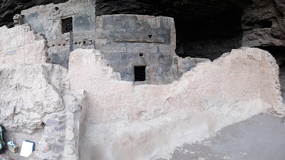
The cave has even preserved the cross-hatch roof in the interior room. These dwellings were originally two story. While we made access to the ruins by a paved path, for the Salado people security was also a factor so they climbed wooden ladders from the path  that could be withdrawn if danger was present.

The original roof is behind this wall along the horizontal board and continuing on where you see holes. these holes also accommodated poles for the base layer of another roof. The small opening above the doorway is for smoke to escape from cooking fires. 

These doorways are much smaller than the openings at the cliff dwellings we saw at Bandelier National Park last year near Los Alamos. 


No comments:

Post a Comment