Followers

Friday, December 20, 2019

2019 11 20 - 11 26 Hoover Dam

Hoover Dam, Black Canyon, Clark County, Nevada - 20 November 2019


The bypass bridge was opened in 2010 across the outflow of the Colorado River from the Hoover Dam. This allows traffic to flow continuously on the highway instead of the old 2-lane road that winds around. It also gives visitors a great view of the dam, towers and spillways. 
Fortunately, the rain we had driven through for 90 minutes had finally stopped so we had a great view of the everything including Lake Mead. Constructed in the 1930s by 21,000 men, the dam is 726 feet tall and 660 feet thick (at the bottom) and holds back the water pressure of 45,000 pounds per square foot. At 4.5 million cubic yards of concrete, that is enough to build a four-foot wide sidewalk around the Earth at the Equator. 
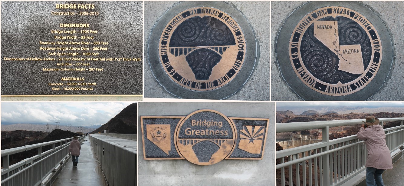
Just the facts, Ma'am. And there are plenty of them. Named after the former Nevada Governor Mike O'Callaghan and former NFL player and U.S. Army Ranger. Spanning the Black Canyon between Nevada and Arizona, the bridge is nearly 900 feet above the Colorado River. It is the seventh highest bridge in the world.
 
A statue of a worker in harness called the "Dam High Scaler Monument", a larger-than-life, fearless, worker who would dangle hundreds of feet in the air, armed with jack hammers to jar loose rocks and dynamite to blast away at the canyon walls. And the faithful mascot who spent years along side the workers.

The Memorial to the 96 men who died in the construction of the dam. The low-relief panel by sculptor Oskar J. Hansen, edicated in 1935, shows  naked man emerging from waves in front of the dam. A thunder cloud spits lightning bolts, stalks of grain sprout, and fruits and vegetables flourish. The monumnet states: "They died to make the desert bloom." Intake towers on the Lake Mead side. The multistory Visitor's Center which opened in 1995 houses exhibits explaining how the dam operates and elevators for tour access to the Powerplant. And the Winged Figures of the Republic, dedicated in 1935, created by Oscar Hansen and made of more than 4 tons of bronze. The wings are about 30 feet tall, they may be angels, demons or far-future humans. The monument is surrounded by a terrazzo floor with a celestial chart showing the exact position of key stars on the day the Hoover Dam was dedicated by President Franklin D. Roosevelt. 
Panels on the elevator towers shows the purposes of the dam: flood control, navigation, irrigation, water storage and power.
On opposite sides. I'm on the Nevada side and Bob is on the Arizona side. 

The Desert Princess, an authentic, three level, Mississippi-style paddle wheeler built especially to cruise on Lake Mead. At its highest point, Lake Mead elevation reached 1220.45 feet above sea level and was 580 feet deep, 120 miles long. 


A replica of one of hundreds of containers used to deliver the 4,360,000 cubic yards concrete in the dam, powerplant and appurttenant works between 6 June 1933 and 29 May 1935.
On tour with our guide, the diagram shows the internal workings of the dam, generators and spillways. The four diversion tunnels behind the canyon walls were fifty feet in diameter during construction of the dam. Afterwards, one-third of the inner tunnels were plugged with concrete and now contain 30-foot-diameter steel pipes (called penstocks) which connect the intake towers in the reservoir with the powerplant and conyon outlet-works. The two outer tunnels are used for spillway outlets.   
One of two powerplant wings. Each is 650 feet long and rises 229 feet. The 17 main turbines--nine on the Arizona side and eight on the Nevada side--having a combined rated capacity of 2,991,000 horsepower or 2,080 megawatts. The average annual generation from 1947 through 2008 was about 4.2 billion kilowatt-hours. Smaller generators are used for moving machinery in the powerplants. And the inner steel pipe of the penstock. We could even hear the water churning through the pipe. 


Wednesday, December 4, 2019

2910 10 28 - 11 18 Salome, Bullhead City, Oatman and Lake Havasu City, AZ

Salome KOA, Salome, Arizona - 28 Oct - 02 Nov 2019
Lovely skies over Salome KOA. A pair of hikers at the Buttercup Sand Dunes, part of the Imperial Sand Dunes Recreation Area used for Off-Road Vehicles. Water fill and dump stations allow people to just pull off the highway and explore the dunes while living off the grid. FUN FACT - The location in Butternut was used during the making of Star Wars: Return of the Jedi when stuntmen take the plunge into the Sarlacc, a creature buried in the Great Pit of Carkoon, except for its massive mouth and beaked tongue. Jabba the Hutt entertained himself by forcing prisoners into the creature's tenticled maw.

A few more serene views near Salome is the variety of hummingbirds that arrived at our feeder, the ultralight flying over past our campgrounds and the open desert behind the KOA for walks with the dogs. Nearby is the town of Quartzite, the famous RV boondocking (no hookups) capital of the world and a two month long gem show and swap meet

We took advantage of a small but warmly heated pool and spa. We had to swim during the "heat" of the day since the less than 10% humidity chilled us quickly.  
Pretty aromatic roses lined the walkway back to our RV.

Colorado River Heritage Greenway Park, Laughlin, Nevada - 6 Nov 2019
Another good spot for a walk, getting us all out in the fresh air along the Colorado River, Laughlin on the west side and Bullhead City on the east side. 
A well maintained path makes for a very enjoyable long walk.
The Colorado River is dammed in to provide seven states with irrigation, flood control, hydroelectric power and regulation of stable flow downstream. Ninety miles down from the Hoover Dam is the Davis Dam, an earth-filled dam with a concrete spillway. Its purpose is to re-regulate the releases from the Hoover Dam and facilitate the delivery of water to Mexico. Bullhead City was originally a construction townfor workersbuilding the dam. 
At 1,600 feet in length and 200 feet high, the dam begins on the Nevada side, but it does not extend to the Arizona side on the east. Instead, there is an inlet formed by earth and concrete, that includes the spillway. The hydroelectric power plant is beside the inlet.

Airbnb in Bullhead City, Arizona - 6 Nov-22 Nov 2019

Two Bedrooms, two baths
Living room, kitchen and full laundry
Backyard with a patio.
Oatman, Arizona - 11 November 2019
An old mining town, founded about 1906, producing over 1.8 million ounces of gold by 1931. The boom was over by the mid 1930s and the last remaining were closed in 1942 as nonessential to the war effort. 
Burros first came to Oatman with early day prospectors, the animals were also used inside the mines for hauling rock and ore. Outside the mines, burrows were used for hauling water and supplies. They were released into the surrounding hills. 
The town's roaming burros are descendents of the domestic work animals. People drive for miles to see and feed these wild burros. The foals have stickers on their foreheads asking that they not be fed. We presume they are still nursing and introduction of pellet food would disrupt their digestive tract. 

Lake Havasu City, Arizona - 12 November 2019
The gate dates from 1862, fountain and dragon boundry posts, established in Roman times, mark the boundary of the City of London Land in Lake Havasu City. 
In 1968, England discovered that its iconic London Bridge was falling down. Robert McCulloch, a Missouri-born industrialist, had a penchant for pie-in-the-sky schemes. He had purchased thousands of acres of land near Lake Havasu, Arizona with designs of making it a tourist oasis. He concluded this was just the eye-catching centerpiece needed. Carving one of the lake's peninsulas into an island so the bridge would have something to span, McCulloch purchased the bridge, labeling each granite brick and shipped to Long Beach, California via the Panama Canal.
Shipping, assembly and dredging cost over $7 million. On 10 October 1971, the London Bridge was ready for its debut. The dedication ceremony included skydivers, fireworks, marching bands, hot air balloons and a dinner featuring lobster and roast beef - the same meal served to King William IV when the bridge was first opened in 1831. London's Lord Mayor attended accompanied by a sword bearer.
A red British phone booth, water-spouting lion fountain and a welcoming spot for our puppies at a local eatery.
The Heraldic Dragon boundary posts. 

Grapevine Canyon on Spirit Mountain, Nevada - 14 November 2019
Known for the hundreds of petroglyphs, the Grapevine Canyon is listed on the United States National Register of Historic Places.
This area features over 700 petroglyphs. Created between 1100 and 1900, their meaning and creators remains unclear although the area was inhabited by the Mojave.
Some rock climbing was necessary and ultimately barred our path as they became too slippery and treacherous for us and the dogs.
Fascinating rock formations. Too bad we couldn't have gone further along the path.