
 |
| At last, we can actually take the dogs with us on a hike. The original route into Fort Bowie was a wagon road built by soldiers garrisoned at the post. Today, we park at the trailhead of Apache Pass Road. |
 |
| The 1.5 mile hiking trail began relatively easy with wide paths that was easy to follow. |
 |
| Desert grasslands dominate the lower slopes. The chaparral is characterized by tough evergreens, which can form dense thickets of silk tassel, manzanita and mountain mahogany. |
 |
| Yucca and prickly pear grow along the hiking trail. |
 |
| After about half a mile along the hiking path, I noticed these two mule deer grazing in the brush. They didn't run off but they weren't interested in getting any closer either. Our dogs are not hunters as they completely ignored them. |

 |
| An overlook down on to the cemetery. All soldiers from the original Fort have been exhumed and reintered in other military cemeteries. |
 |
| It was a surprised to come around a turn to find this Desert Globemallow or Apricot mallow still blooming. |
 |
| Almost at the top, we the pups were glad for a short rest. The grade became steeper and more rocky. All of us were happy for the overcast skies. |
 |
| I made it down this last portion of the trail. We are going to have to hustle through the Fort Bowie ruins. The ruins are outside but they are surrounded by mountains and the sun setting behind them makes for much cooler temperatures and rapidly darkening paths. |

 |
| Fort Bowie and Apache Pass were central to US Army operations against the Chiricahua (Chirr-i-KAH-wa) Apache for control of this region. Two well-known tribe members were Cochise and Geronimo. |
 |
| Ruins of Fort Bowie at about 5,000 feet. Adobe housing and various workshops; tailor, medical facilities (hospital and offices), barracks, dining, a row of officer houses, an officer lounge, supplies, storehouses,corrals with blacksmiths, furrier and saddlers. Even a tennis court. Outside the "official" footprint was a large sutler store, a civilian merchant who sells personal provisions to an army in the field. |
 |
| A large two-story brick house was built for the Commanding Officer and his family. Two daughters were married in that house to Fort officers. |
 |
| A total of 38 structures make up the ruins. Between 1862 and 1886, Fort Bowie was the nerve center for military campaigns against hostile Chiricahua Apaches led first by Cochise and then by Geronimo. |
 |
| Apache Pass a part of the Overland Mail route started by John Butterfield from either St. Louis or Memphis to California with 2,000 employees, over 250 coaches, several hundred wagons, 1,800 horses and mules, and 240 stage stations spaced along its 2,800 mile route. Just imagining rolling down these mountains in the heat of summer or a snowstorm in winter. |
 |
| Before arriving at the cemetery we had to pass Apache Spring, the ultimate reason for Indians, soldiers and travelers, which still delivers its gentle, steady flow of water today. We arrived back at the truck with only about 10 minutes of light left. Driving back to the highway in total darkness those cattle guards across the road can really sneak up on you. |
Butterfield RV Resort, Benson, Arizona - 11 December 2018
 |
| We made four dinners of cannelloni and two dinners of ravioli paired with my homemade marinara sauce. We are getting used to our smaller accommodations. |
Titan Missile Silo, Sahuarita, Arizona - 13 December 2018
 |
| Also known as Titan II ICBM Site 571-7 is a former missile site south of Tucson. A National Historic Landmark since 1994, it consists of underground Launch Control Center, eight level silo containing the missile and connecting structures of access tunnels, blast locks, access portal and elevator. |
 |
| Over my right shoulder is the access portal. To the right of the photo is the missile silo with the steel reinforced concrete hatch. |
 |
| Gary, our guide waits for his partner to go down the access portal to check for rattlesnakes. All clear and we descend down the stairs. |
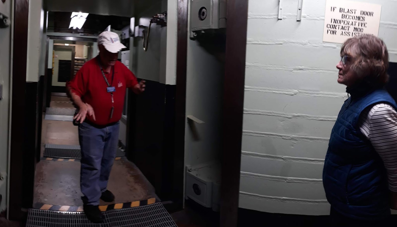 |
| A number of 3-ton blast doors sealed the various areas from the surface and each other. Even after more than 30 years, these doors can easily be maneuvered and retain the 1/4 inch clearance to the floor. |
 |
| As opposed to the two man crew of the Minuteman Missile, the Titan missile station required a four man crew plus many maintenance and security personnel. |
 |
| This long access tunnel is lined with spring-loaded shock absorbers. Several scenes in the 1996 film Star Trek: First Contact were shot at the site. The missile itself was depicted as the launch vehicle for the film's Phoenix spacecraft, the first warp prototype. At one point, Data notes the profound irony that a weapon of mass destruction was used to bring about the global peace and unity of Trek's future. |
 |
| The observation window above the Titan II, a 103-foot missile has neither warhead nor fuel. In accordance with the US/USSR agreement, the silo doors are permanently blocked from opening more than half way. The silo became operational in 1963 and was deactivated in 1984. The other 17 sites around Tucson, with the exception of this one, were demolished along with all others throughout the country. |
 |
| There were no astronauts at any of the silos. These are suits worn by the maintenance crews that worked around the fuel which was very caustic and poisonous. |
 |
| First stage engine, only about 3 feet across exhaust funnel. |
 |
| The engine developed 430,000 pounds of thrust. For all the non-engineers, that's the same power as two 747s running full throttle. This stage ran for about 2.5 minutes, then was jettisoned. By then, it would have been boosted to an altitude of about 50 miles up and 50 miles north towards its target. |
 |
| Stage 2 engine is about 4 feet across exhaust funnel. This stage burned for about 3 minutes to an altitude of 200 miles, then shut down by the on-board guidance system. When this stage separated from the missile, the RV (that's not Recreational Vehicle but Re-entry Vehicle) continued on to the target with the warhead. So, if my calculations are correct, after approximately 5 minutes, the RV coasted the rest of the way to the target over the north pole. |
 |
| Through the look-glass, we could see everything except the engines which have been removed. The black "nose" is the dummy Re-entry Vehicle mounted on the missile has a prominent hole cut in it to prove it is inert. We were told the Soviets see by satellite to verify compliance. |
 |
| There are two of these cones at each corner of the silo. They are Radar Surveillance System called "Tipsies" (TPS-39) which projected a motion-sensing Doppler radar beam and alerted crew to the presence of intruders. |
 |
| A lovely view from the Silo parking lot. |
MAIL CALL, Benson, Arizona - 16 December 2018
 |
| "Night Sky" weaving from our sister-in-law, Julie Douglas. Another homey touch to our new-ish quarters. |
Tombstone, Arizona - 18 December 2018
 |
| Lunch at the Longhorn Restaurant. |
 |
| Decorated for the holidays with photos of the baseball teams (behind Bob) and the basketball team (behind me). |
 |
| Walking around town we passed by Big Nose Kate's Saloon. This is not a description of a physical feature but her penchant for curiosity into other peoples' business. Besides her business, she was a fallen dove (euphemism for prostitute), and longtime companion, common-law wife of Doc Holliday. |
 |
| The stage is set for the "Gunfight at the OK Corral". |
 |
| Morgan, Virgil and Wyatt Earp. |
 |
| Thirty bullets in 30 seconds, the Earps with Doc Holliday (foreground) take down Frank and Tom McLaury with Ike and Billy Clanton, |
 |
| Animatronics outside the stage area. |
 |
| And a collection of buggies, buckboards, wagons and a surrey with fringe on top. |
 |
| What are they going to do with these? Since there are names on them, shouldn't they be in the ground. I mean, it's not like they are reusable. |
 |
| The Mail wagon is now used to drive tourists around for a tour of "The Town That is Too Tough to Die". |
 |
| So many storefronts have become tourist shopping space for silver which was a major reason for the establishment of Tombstone. Over 70 mines were opened nearby and were worked until groundwater started rising. Eventually the pumps could not keep up with the amount of water and the mines were abandoned. |
 |
| The main street is closed to traffic and adorned with a large Christmas tree. |
 |
| City Hall built in 1882. There have been several fires in the downtown area so many of the storefronts are rebuilt. |
 |
| Outside Tombstone is Boothill Cemetery was founded in 1878 but after 1883 only used to bury outlaws and a few others. Tom McLaury, Frank McLaury and Billy Clanton, of OK Corral fame, are buried here. Shocking as this may be but there are notable grave markers but fictitious burials. |


